
Guest reading progress stays in this browser and is not synchronized to your account automatically. Use the learning panel to include browser marks and save them explicitly. Clearing site data removes browser marks.
Your learning notebook
Save courses and review situations deliberately. Load your account records on another device when you want to continue.
Bookmarks and review choices stay in this browser until you load and save an account. Answers and time spent reading are not recorded.
Saved courses
Saved situations to revisit
Find your marked situations by title or topic, then open the original question and explanation.
Your review choices will appear here when this learning view is ready. Use the account controls above to load account choices.
No situations are marked for review in this learning view.
No saved situation matches these filters. Clear the search or choose all topics.
Identification practice
Land access practice
Field decisions practice
Harvest care practice
Useful reading before this lesson
Start with these guides for background and preparation. You can open any guide at any time.
A first wetland outing: check the final approach and the way back ↓
A first wetland outing: check the final approach and the way back
Rowan and Casey plan a fictional shore visit. Its final approach has changed. At home, their four-column card separates permission, current conditions and return.
Original planning exercise, not a road inspection or authorisation to enter. No route, parking place or crossing is approved. Rehearse on a map before travelling; check actual conditions and the responsible authority.
Make the decision before the uncertain section
- Name each segment
Separate the highway, final approach and parking.
- Match the evidence
Record who confirmed access and what condition was checked.
- Keep a dependable return
Identify where the plan ends before uncertain ground.
- Stop or replan
Choose a separately checked alternative or return.
Focus the table and use arrow keys to read the four columns on a small screen.
| Segment or task | What is recorded | What remains unresolved | Next decision |
|---|---|---|---|
| Destination permission | Consent for the named parcel and activity. | The chosen approach and parking were not discussed. | Ask about those separately before departure. |
| Main highway | A dated Highway Hotline check. | Conditions on the final local segment. | Identify its responsible authority and check that segment. |
| Final approach | An old photograph shows a dry surface. | Today’s water, surface and available stopping place. | Do not use the old image as a current inspection. |
| Return | A checked way back in the original plan. | Whether weather or a route change affects it. | Reassess before extending the visit. |
Rehearse three things before leaving
- Draw destination, approach, parking and return separately. Ask Casey which person or source supports each entry. Keep a missing answer visible instead of joining the lines into a confirmed route.
- Read a current official road update and its coverage together. A highway report and a local approach are different scopes. Write the checked time and the unresolved segment; identify whom to ask before travelling.
- State the stopping decision aloud. A fallback needs its own access, parking, conditions and return checks. If those are missing, it remains a candidate rather than an automatic detour. Leave room to cancel the outing.
Work through three changes
The agreed gate has changed. Does parcel permission settle the approach?
The group’s note names the parcel, but the gate arrangement no longer matches it. A navigation line still crosses that point. Neither entry answers who can authorise this approach or where the group may park.
Keep the access question unresolved and contact the authorised person before using a changed arrangement. Do not invent another entrance from the map. Review a separately confirmed alternative or cancel the visit.
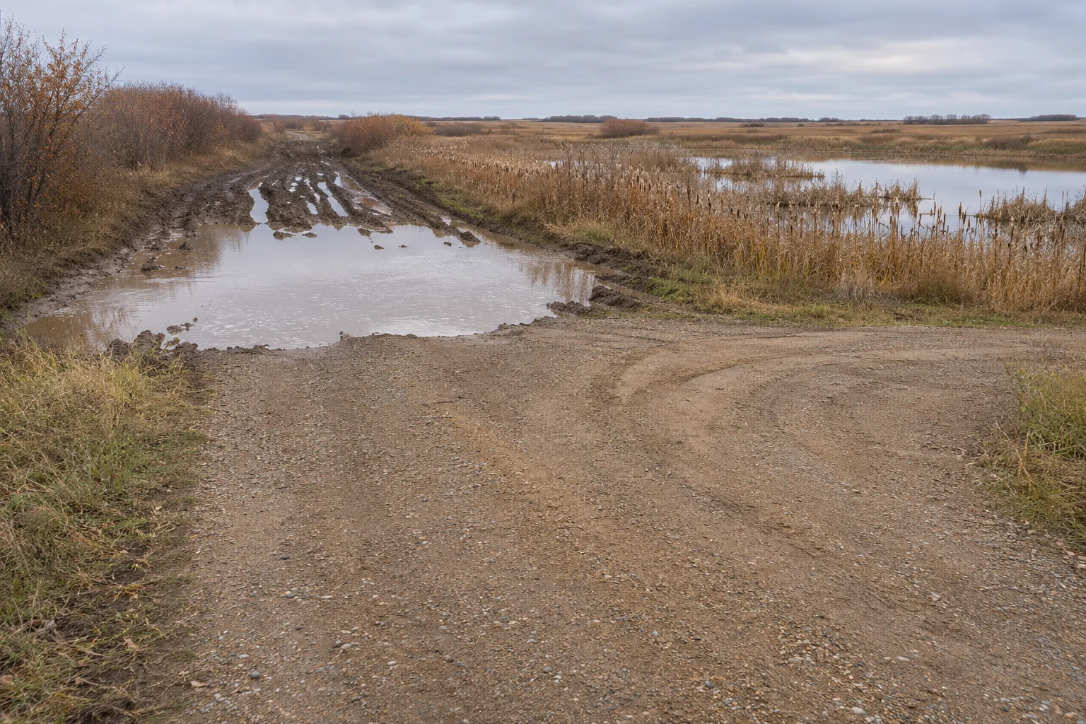
The shoulder is soft and water covers the final segment
The highway status looks suitable, but the final approach differs from the saved photograph. Another vehicle’s tracks do not establish the surface, depth or condition ahead. A road-status report is not an inspection of this local segment.
Stop that approach before uncertain ground, without obstructing traffic or access. Do not drive or wade through water to test it, or improvise a shoulder bypass. Use a separately checked alternative or return.
The forecast changes after the group arrives
The party planned its return under an earlier forecast. A later update raises a question about that journey. The original card records a past check; it is not a promise that conditions remain unchanged.
Review the return while dependable options remain. Shorten or end the visit when the plan no longer works. Update the companion and check-in arrangement; do not borrow return time to reach the original observation goal.
Original AI-generated teaching scene. The gear, map and landscape are illustrative; they do not show current local conditions or a verified route.
Image credit: SKHunter · original AI-generated teaching sceneWhat you will learn
- Separate highway information from a checked local approach.
- Recognise an unusable road or shoreline without testing it with the vehicle or body.
- Plan a lawful alternative that preserves a dependable return.
An original SKHunter learning guide
Treat a changed approach as a new decision
The route that reaches the destination must also support a controlled return. A map line does not establish that route.
Preparation and decision sequence · read the complete lesson for context.
Work through the example
- 01
Check the route information
Consult current road and public-safety information, then compare it with the exact approach and vehicle.
- 02
Pause before altered ground
Floodwater, soft shoulders, wet shore or an uncertain frozen surface are reasons to stop and reassess from checked ground.
- 03
Use an already checked alternative
An alternative needs its own access and ground checks. Turn back if no usable option has been established.
- 04
Record the change after returning
Update the private entry or route note with the date and actual observation so an old plan is not reused unchanged.
Rehearse your own decision
Describe the evidence first, then decide what needs checking before another visit.
- Is the route usable for this vehicle and party, including the return?
- Have you avoided treating water depth, ice appearance or a map track as proof of a safe crossing?
- Would your alternative cross land or ground that has not been checked?
Check each part of the journey with the right source
List the highway, municipal road, private approach and walking section separately. Use Highway Hotline for the highway information it publishes, then confirm the relevant local road and access arrangement. Read the report time and affected segment; a green-looking highway cannot answer a question about the last farm track.
Look at current weather and official restrictions before departure. Keep the local contact’s dated information with the route record. A map showing a road is a lead to check, not evidence that the road is passable, maintained or available to your vehicle on that day.
- Record road segment / source / time checked / unresolved question.
- Treat the final approach as its own decision.
Choose a stopping and parking plan before the soft section
Identify a place you may use without obstructing traffic, gates or farm operations. Decide where to stop if the surface or visibility differs from the plan. Make the choice while you still have a usable return route rather than after driving into an uncertain section.
An apparently short muddy stretch may hide damage or make turning difficult. Do not use vehicle capability, another driver’s tracks or a navigation instruction as a test of permission or current passability. If a route is closed or unsuitable, end that approach and reconsider from an appropriate safe place.
- Keep access and emergency routes unobstructed.
- Do not drive around a closure or into floodwater to check its depth.
Make the shoreline visit a firm-ground activity
For a shore-based visit, identify the observation position, the approach and the route back on ground you have actually checked. Keep equipment handling away from an unstable edge. If the ground becomes soft, flooded or difficult to leave, stop the approach instead of testing how much farther it might support you.
Before starting a hunting activity, include lawful retrieval within the party’s real capability and site conditions. A bird or object beyond the checked ground does not create a safe route to it. Buying waders or seeing shallow water in a photograph does not resolve footing, depth, current or cold exposure.
- Keep a clear return to the checked dry approach.
- Change the activity or leave if retrieval depends on an unprepared water entry.
Keep ice out of a shore-based shortcut plan
A familiar pond can change between visits, and a surface that looks solid from the bank does not establish its condition throughout. WSA warns that ice can vary and that moving water, thawing and other conditions affect it. This lesson deliberately provides no ice-thickness calculator or permission to cross.
For this land-based plan, treat frozen water as a boundary and use a separately checked land route. If reaching the destination requires ice travel, change the plan and obtain appropriate current local information and training. Do not test unknown ice by stepping onto it or sending a companion first.
- Keep people and dogs under control away from uncertain edges.
- Do not attempt an improvised water or ice rescue; call for emergency help.
Build an alternative before it is needed
Choose a second activity or destination while still at home. Check its complete access, approach and return independently. Moving a few kilometres to another wetland can create a new set of land and road questions; the first landholder’s agreement does not automatically cover the alternative.
On arrival, compare the observed conditions with both plans. A dry-ground observation visit, a shorter walk or returning home can be the useful option. Record a cancellation as a decision with a reason, rather than treating it as a failed day that must be recovered by taking a less certain route.
- Write what makes plan A unusable and what must be checked for plan B.
- Keep enough time and fuel for the chosen return.
Leave a dated record that helps the next visit
After leaving, note exactly what was seen from the lawful position: water over the road, an unusable surface, an unexpected gate or soft shoreline. Separate the observation from a guess about depth, ownership or how long the problem will last. Add the report source and date alongside the personal observation.
Update private route notes and inform the responsible service when appropriate; use emergency services for an emergency. Before returning another day, check fresh reports rather than treating your old note as a current closure notice. The aim is a repeatable decision process, not a permanent judgement about the whole area.
- Write observation / decision / next source to check.
- Keep photographs free of unnecessary private contact details.
Practice case: the highway is open but the final road is flooded
Highway Hotline shows no highway closure for your drive. At the final local approach, water covers the road and the planned shore position cannot be reached on checked firm ground.
Put it into practice
- Stop before the flooded or uncertain section without obstructing the road.
- Do not drive or wade through the water to test the route.
- Review a separately checked alternative or return using the dependable route.
- Keep any activity on checked ground; do not improvise an ice or water crossing.
- Record the affected local segment and check the responsible authority before another visit.
Common mistakes to avoid
The highway report covers the final farm approach
Match each road segment to its actual source and current local information.
Tracks across the surface prove it is usable now
Another vehicle’s passage does not establish your access, footing, ice condition or return.
Cancelling means the day taught nothing
An accurate dated route observation can improve the next plan without adding exposure.
The highway is open, but floodwater covers the local road to the parcel. What is the useful decision?
- Stop that approach and use a separately checked alternative or return.
- Drive slowly through because the highway has no closure.
- Walk through first to decide whether the vehicle can follow.
Show the answer and explanation
Answer: A. Stop that approach and use a separately checked alternative or return.
The final approach has its own conditions. A highway status cannot establish the depth, damage or safety of a flooded local road.
Current checks and official context
Current reports and restrictions
Highway Hotline and SPSA incident maps link to changing official information. Check the affected segment and time; this article is not a live closure or road-condition service.
Water and ice scope
PHAC and WSA provide the linked public-safety guidance. This land-based lesson teaches planning and stop decisions, not wading, ice assessment or rescue techniques.
Turn this lesson into your next outing
Review the date, species, starting template and linked day plan in an editable preparation draft. You choose what to add and save.
Prepare your own trip
Review a preparation draftContinue learning
Ask for land access and keep a useful permission recordTry a practical situation
A clear view beyond the recovery limitOpening a draft does not create a saved checklist. A checked item records your own review, not permission or an open season.
Scenario practice
Put your field decisions into practice.
Try 24 situations across identification, access, field adjustments and harvest care. Compare your choice with the explanation, then revisit the relevant lesson.
Original sources
- Government of Saskatchewan · Highway Hotline information and coverage
- SGI · Winter driving and road-condition checks
- Public Health Agency of Canada · Floodwater and public safety
- Saskatchewan Water Security Agency · Ice conditions and uncertainty
- Saskatchewan Public Safety Agency · Current incident and restriction maps
- Saskatchewan Public Safety Agency · Sask911 and wireless limitations
Use this as a planning guide. Check current official requirements and site conditions before travelling.
Help improve this guide
Tell the editor about something on this public page that needs attention.